
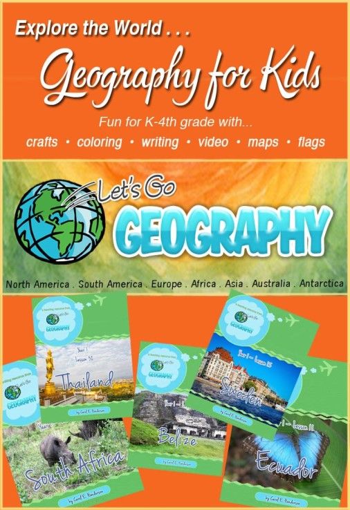
Let's Go Geography is suitable for elementary-aged children in K-4th grade. The curriculum is intended to be used once a week for about an hour. Keep reading my review to see how we used it.
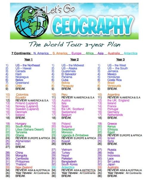
Two features of this geography curriculum for kids that you might appreciate are the breaks and reviews. Breaks allow the child time to finish all the projects up to date or to schedule a week without Geography lessons. Review lessons cover and summarize content previously taught. Some new basic map skills are also introduced. The 36-week program includes 4 break weeks and 4 review lessons. Week 9 is the first break week and Week 12 is the first review lesson. The first three review lessons cover previously learned material addressing two continents at a time and the last review session reviews material for ALL continents. The curriculum is organized and divided into two 18-week semesters. Each lesson serves as a stand-alone product. The lesson content does NOT build on each other.
This curriculum offers plenty of content to use throughout an entire school year. Each lesson studies one specific country and includes map work, engaging activities, educational video links, a photo album highlighting beautiful landmark images, featured hands-on crafts, optional literature recommendations based on library call numbers, related country-specific coloring pages, and online website suggestions to further research. The company also offers Internet Safety Precautions to read over before you start. I highly suggest reading it.
Access to all PDF formatted files is given to one teacher for homeschool usage and/or all co-op classes taught through the online subscription. You can login and download each individual lesson for the entire year one by one if desired. All weekly lessons are formatted in a similar fashion. The Table of Contents shows you how the material will be presented. The Table of Contents for each weekly lesson is organized into seven sections which includes 6 chapters. The review lessons do not include the Music chapter.
- Are You Ready?
- Chapter 1: Map It!
- Chapter 2: The Flag
- Chapter 3: The Music
- Chapter 4: Let's Explore
- Chapter 5: Create!
- Chapter 6: Printables
 |
| Click to Enlarge |
Carol Henderson was a homeschooling mom for 25 years. She now has 5 grown-up children. She is currently teaching Geography and History in a large co-op classroom setting. She posts useful resources on her other website called ABookinTime.com and is the author of Let's Go Geography.
I received an email with a coupon code to purchase the subscription. I have unlimited access to the digital content for one-year. I had no problems accessing the content or materials. I opened the link on my Mac OS X 10.11.6 which is an early 2009 computer. We prefer using Chrome as our browser and Adobe Reader was necessary to open and save the PDF downloadable files. You'll definitely need a stable Internet connection and a printer.
The curriculum was used with my nine-year-old daughter who is currently in 4th grade. She is at the tail end of the suggested age range, but since the content was all new and we've never studied individual countries in depth I knew it would be beneficial to our homeschool. She worked through the majority of the materials independently. This was her core World and US Geography curriculum for the summer and the new school year.
Travel Journal and Divider Tabs
My daughter first chose a cover for her Travel Journal which stored all the completed weekly activities. She was given four different cover design options. We printed the cover in color on cardstock paper and placed it at the front of a two-inch 3-ring D binder in the clear overlay pocket. Notes are scattered throughout the curriculum reminding you of items to store in the binder. This will be an awesome keepsake at the end of the year and will make it easy for Alyssa to share her work with her father. I hope to photograph all of the hands-on featured crafts so that she can include them in the binder. I wish there was a decorative journal printable page for this purpose. She could label the photo and write about the craft.

- North America - Blue
- South America- Red
- Europe - Orange
- Africa - Green
- Asia - Yellow
- Australia/Antarctica - Purple

Passport
Then, Alyssa assembled her Passport. We also received the passport printables with the reviewer coupon code we were given. She followed the directions to create it. The passport offered space for a head shot photo. At the time of this review, the author also offered the passport printable as a freebie if you shared her Let's Go Geography curriculum on social media. The passport printable can also be purchased separately through their online store.
 |
| Country Flags Glued on Continent Pages |
We covered one lesson each week. My daughter worked on the Geography lesson three days each week. A fourth day was used to catch up if needed. The amount of time spent working on lessons each day varied from 30-90 minutes. There is no way we could complete ALL the activities on ONE day within an hour, because she tends to dawdle and take rabbit trails when exploring. Thursdays and Fridays were considered our catch-up days if needed. I believe it would be best to spread out the activities over 2-5 days for younger students in K-3rd grade. We worked through the lessons in sequential order. The first place we visited was the Northeast region in North America. We completed five lessons during the review period. We learned about the Northeast, Hawaii, Canada, Haiti, and Nicaragua. Today is our last day of our Belize study.
Review Week
Week 12 is the first review week which covers North and South America content. The 30-page lesson introduces and reinforces basic map skills including but not limited to understanding latitude and longitude, labeling compass rose directions, and identifying the Equator.
The review begins with basic fact sheets for North and South America including information about the square miles compared to the USA, first three common languages, and the continent. A Travel Itinerary is also provided with completion check off boxes. No featured crafts are offered during the review weeks. Two coloring pages are provided which gives children more time to catch up on previous lessons. Children who like animals will enjoy these printables. Educational links about particular animals are included for further study. My daughter will love this feature! They can learn more about the animals if desired. As with the other weekly lessons optional reading suggestions from the library are given based on the call number and online reading resource links are added to the lesson.
Alyssa will identify, color, and label countries on blank printable maps. Helpful map links are provided. Then, my daughter will complete a map activity page about latitude and longitude. Next, she will match flags to their corresponding countries for both North and South America. The author includes a Let's Explore North and South America section. Interesting facts are mentioned. The child will then match pictures seen during exploration to the corresponding country. All answer keys and printables are included for activity sheets and lessons.
Remember the goal of this curriculum is NOT mastery it is exposure. The more we expose our children to the world around them the more educated and culturally aware they will become.
Haiti: A Glance at a Weekly Schedule
Before I show you how we utilized the curriculum I wanted to share another cool curriculum feature with you. A Trip Itinerary is a checklist provided at the beginning of the lesson so that your child can mark lesson components off the list once completed and track her progress. You can see an example of the Haiti Travel Itinerary below. My daughter places a checkmark in each box after completing activities.

We begin the lesson with the Are You Ready? page. Alyssa read aloud this fact information sheet. Basic information was listed about Haiti such as the continent, capital city, largest city, language, population, and number of square miles. She learned that Port-au-Prince was the Haiti's capital and largest city.


Day 2: Online and Literature Research & Notebooking Sheet
On the second day, Alyssa was required to login into the subscription website or to open the file to research information about the country, Haiti. She would usually login at the beginning of the week to download the file into iBooks on our iPad. Then, she would open the file later in the week. She visited the links as she read the material. She kept a scrap piece of paper nearby so that she could jot down information about the country. The notes were turned into a handwritten paragraph and the final draft was written on the open-ended notebooking sheet. I didn't really set any strict expectations for this page. I told her to write down interesting or fascinating facts she learned about the country after exploring the location. The Photo Album is a gallery of images seen during the exploratory phase. The scrapbook photos are included in the binder. These pictures include descriptive captions.
 |
| Research on iPad for Notebooking Sheet |
 |
| Photo Album |
The third day was her favorite day. She read the short paragraph about the area before beginning the coloring pages and crafts. For example, the Haiti color sheet fact was that the primary cash crop for Haiti was coffee, but other crops Haitians grow for food include corn, rice, and sweet potatoes. She had fun coloring the Haitian farming scene. The coloring pages were related to the country and what you might see, hear, visit, or experience. The coloring pages were usually found under the Printables sections of the lesson or through an online link.
 |
| Haiti Coloring Page |
Then, she would gather materials for the country's featured craft. Next, she would work on the featured craft using the step-by-step instructions. A link to the original craft instructions was provided if available. Occasionally crafts would run over into the next day. The featured Haiti craft took her two days to complete, because she wanted the artwork to dry overnight instead of only giving it a few minutes to dry.
Alyssa colored a Haitian Market Art coloring page using bright colors as indicated in the directions. Then, she used black watered-down watercolor paint to cover the entire the image. The crayons resisted the watercolor paint and filled in the background. My daughter pasted it down on bright colored orange paper the next day. She wrote Haiti at the top of the page.
 |
| Haitian Market Day |
- Hands-On Featured Crafts
- Detailed Coloring Pages
- Differentiated Map Work with Leveled Questions
- Clear Step-By-Step Directions
- Captioned Photo Album Scrapbook Pages of the Country's Landmarks
- Built-In Break and Review Weeks
- Progress Tracking Checklists and Online 'Lesson Completed' Widget
- Ability to Pick and Choose Activities based on my Child's Learning Preferences
- You Don't Have To Do Everything
- Same Organized Layout Each Week
Her least favorite activity was the Maine Lighthouse craft from the Northeast study. The craft didn't really capture her interest and she felt like it didn't look like a lighthouse. She was a little frustrated with the watercolor paint used on the Canada Maple Leaf craft. I suggest trying tempera paint with younger children. The watercolors will bleed and blend quickly if too watery.


Recommendations
I HIGHLY recommend Let's Go Geography to homeschool families and co-ops. It can easily be implemented in a class room setting or utilized in the homeschool environment. It is an excellent geography curriculum for kids. The program was intended to be completed in sequential order, but it can be easily adapted so that you skip around to desired countries and choose only activities your child will enjoy. I believe this curriculum can be utilized as a complete core or supplemental Geography curriculum. Hands-on learners and children who prefer online learning may benefit from using this curriculum. If you have a child who loves studying faraway places around the world - I would definitely look into this curriculum. My daughter is already asking me if I'll purchase Year 2 and Year 3 in the future.
Overall Thoughts
Alyssa thoroughly enjoyed using this curriculum. She was engaged in the learning process and retained more information about the countries across the globe than I ever expected. I was impressed and pleased with the well-organized content. The curriculum was user-friendly too. We will definitely continue using Let's Go Geography this year at a pace of one country per week stretching the lesson out across 3-5 days. We appreciate that the curriculum can be accessed on either a computer or an iPad. We are eager to learn more about our world using Let's Go Geography!
 |
| Online and iPad Research Showing me Nicaraguan Coffee on the iPad |
Vendor Suggestions
- I wish 1-3 recipes were included for each country.
- I would love to see a hands-on 50 states study created in a similar format.
- Add decorative or bordered photo journal pages. Students can glue a photo of the finished craft on the page. Then, they can label and write about it. Unfortunately, we can't keep the crafts forever.
- Offer more featured craft options for the Northeast region which covers several different locations.
- Give subscribers easy access to one printable PDF downloadable file that contains all the lessons. If this file is too large, then it could include 4-5 separate files. I wish that I could quickly download everything and save the files in one sitting rather than having to visit the website each time I want to download and save.
You can access Year 1 for $21.99. This price includes the FREE bonus travel journal printable covers and full access to all lessons for one 36-week school year. Visit the online store link above for other purchase plans.
Note: All prices are subject to change without notice.
Facebook Tag: @letsgogeography
Pinterest Tag: @letsgogeography
If you want to hear more about Let's Go Geography, then visit the Homeschool Review Crew Blog to read more reviews.


No comments:
Post a Comment